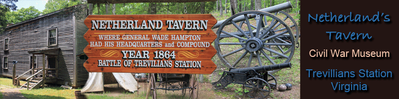
Netherland Tavern Historic Marker erected by the Virginia Civil War Trails. The innscription reads:
The Battle of Trevilian Station Hampton’s Headquarters
Fifty yards east is the site of Netherland Tavern (ca. 1822), which was demolished in the 1950s. The tavern served travelers on the Fredericksburg Stage Road and the Louisa Court House Road to the south. It also served rail passengers after the Virginia Central Railroad started operating in the 1850s. During the Civil War, Netherland Tavern became a center of military activity as the conflict entered its final year.In June 1864, Union Gen. Ulysses S. Grant ordered Gen. Philip H. Sheridan to lead two cavalry divisions west from Cold Harbor in Hanover County, destroy Virginia Central Railroad track, unite his force with Gen. David Hunter’s infantry at Charlottesville, and return with him to the main army. Confederate Gen. Robert E. Lee, learning of Sheridan’s departure on June 7, dispatched divisions of Gens. Wade Hampton and Fitzhugh Lee in pursuit.
Original foundation and site of the tavern Former site and foundation of the tavern Hampton, commanding the expedition, made his headquarters here at the tavern on the evening of June 10 and spent the night sleeping on a carpenter’s bench outside the front door. Sheridan, to the north, reached Clayton’s Store (present-day Oakland) the same night, and only a few miles separated the two forces. At dawn on June 11, Hampton was awakened by two of his subordinates, Gens. Matthew C. Butler and Thomas L. Rosser. When Rosser asked Hampton what his plans were, Hampton replied, “I propose to fight.”
Netherland Tavern is where General Wade Hampton slept the night before the bloodiest cavalry battle of the Civil War was fought. The tavern was also used as a hospital for the wounded. This replica of the tavern was rebuilt on the site and furnished by Russell B. Anderson.
Where Did the Depot Stand at Trevilian Station?
Blue and Gray Magazine, Vol. XIX, Issue 3, Winter 2002
By Eric J. Wittenberg
There are two likely choices for where the Trevilian Station train depot stood in June 1864. The first spot is where all of the traditional accounts place it, on the north side of the railroad tracks, across from the present post office and adjacent to Charles Goodall Trevilian’s house. The other likely choice is at the West Crossing of the Fredericksburg Rd. over the railroad tracks, a few yards from the Netherland Tavern. After much reflection and time spent on the ground, I have concluded that the depot sat at the West Crossing and not where the traditional accounts place it.
Jed Hotchkiss, the famed mapmaker for Stonewall Jackson, had one of his assistants make a map of the area in 1863, but it does not indicate the location of the depot. Every map of the Battle of Trevilian Station done to date that shows the depot, indicates that it sat by the Trevilian house, but, as set forth below, that does not make logical or historical sense, particularly in light of the terrain in the area.
There are a variety of reasons for this conclusion. First, the original Netherland Tavern predated the Virginia Central Railroad. It was the only significant inn in the area, and served all travelers, including those on the railroad, the Fredericksburg Rd., and the Gordonsville and Charlottesville roads. The Netherland Tavern neighborhood was, therefore, a thriving little area dedicated to serving the needs of travelers. When the Virginia Central Railroad came through Louisa County, the tavern became the only local hostelry to cater to railroad passengers. The Trevilian house and the site suggested by traditional accounts is more than a mile from the Netherland Tavern. It would not make sense to make travelers walk, or ride, more than a mile to find lodging. If the depot was located at the West Crossing, as I believe it was, it would have been right next to the Netherland Tavern, an arrangement that makes infinitely more sense.
Second, the 1864 depot was a new structure at the time of the battle. Federal troopers under Brig. Gen. John Buford had burned the depot in May 1863 during the Stoneman Raid, which was part of the Chancellorsville Campaign. The depot was destroyed again on the morning of June 12, 1864, during the Battle of Trevilian Station, and rebuilt a second time. Perhaps when it was rebuilt the second time, it was placed on the north side of the tracks near the Trevilian house.
Third, accounts of participants in the battle do not support the placement of the station near the Trevilian house. A close and careful reading of Maj. Gen. Philip H. Sheridan’s reports demonstrates that Sheridan firmly believed he had driven off Wade Hampton and his Confederates on June 11. In fact, Hampton fell back to a position that is approximately 500-600 yards from the present location of the post office building-the same position where most maps now place the wartime depot. Brig. Gen. Matthew C. Butler had his headquarters in a position that would have been visible from the station. Accounts by Union horse soldiers all indicate that they captured the depot at the end of the day (June II), and that Sheridan established his headquarters at the building. If the depot was located by the Trevilian house, Butler’s bivouac certainly would have been visible to the Union soldiers, only a few hundred yards away, and, therefore, they would not have been under the illusion that they had driven the Confederates away.
Conversely, if Trevilian Station was located at the West Crossing, where I believe it was, it would have been nearly a mile and a half away from the spot where Butler had his headquarters, with a bend in the Gordonsville Rd. and some higher ground blocking the direct line of sight. It is quite logical that Sheridan then might have believed that he had driven the Confederates from the area, if his headquarters was more than a mile from the enemy front line. Thus, the numerous Northern accounts suggest – without saying so explicitly – that the depot was at the West Crossing.
In particular, the men of the 10th New York Cavalry of Col. J. Irvin Gregg’s brigade were quite adamant about claiming credit for capturing the depot. If the depot was located at the West Crossing, it would have been in the direct line of attack of Gregg’s brigade on the afternoon of June 11. If it was located adjacent to the Trevilian house, the New Yorkers would have had to split off from the rest of Gregg’s column, swing to the west of Merritt’s and Devin’s brigades, and attack the far western flank, separated by two full brigades from the rest of their own brigade. That absolutely makes no sense.
Furthermore, the accounts suggest that Lt. Col. Joseph McAllister of the 7th Georgia Cavalry in Hampton’s Division, died while defending the depot. Accounts also indicate that he died very near the Netherland Tavern, in the vicinity of the West Crossing, and that his body was temporarily buried in a shallow grave on the side of the Gordonsville Rd. Again, this only makes sense if the depot was located at the West Crossing.
The final, and most persuasive, factor is the terrain itself. Lt. Carle Woodruff, who commanded a section of Lt. Alexander C. M. Pennington’s Battery M, 2nd U.S. Artillery, drew a map in 1893 in support of the Medal of Honor application submitted by Woodruff on behalf of Cpl. John M. Kennedy, who served in Pennington’s battery. The map shows all of the positions of Battery M during “Custer’s First Last Stand.” If the depot was located at the West Crossing, the guns would have sat on commanding high ground across from the present-day site of an old drive-in theater along the Gordonsville Rd. This is a position that any competent artillerist would have craved as an artillery platform and is a very logical spot to deploy the guns.
Conversely, if the depot was located near the postwar station, the guns indicated on Woodruff’s map would have sat at the bottom of a bowl, in low ground. If artillery was deployed in this low ground, the barrels of the guns would have had to be elevated just to reach level ground, let alone to be effective. It is a position that no sane artillerist would have chosen for the deployment of his guns, and one certainly not used as a deployment of guns for a pitched battle such as the one waged during “Custer’s First Last Stand” on the morning of June 11, 1864.
When I factored all of these things into my analysis, I came to one conclusion: The June 1864 Trevilian Station depot could not have stood at the oft-indicated location next to the Trevilian house; it could only have stood at the West Crossing, near the Netherland Tavern. Any other location simply does not make logical or historical sense. Accordingly, for purposes of this article, I have placed the depot at the West Crossing, and not at the location shown on all prior maps of the Battle of Trevilian Station, including the ones that appear in my book on the subject. (In fact, during my visit to the site with Blue & Gray to layout the Driving Tour, Editor Dave Roth handed me his copy of the book, had me indicate on a map where I thought the depot should be placed, and then had me initial it. All of the maps in this issue show the depot at that exact spot.)
I will undoubtedly stir some controversy, as I am disputing “settled history,” but I stand by my conclusions.
Special thanks to Eric J. Wittenberg for the use of this article.
All Rights reserved